


SPC Mesoscale Discussion
SPC MD 534
MD 0534 CONCERNING TORNADO WATCH 140...142... FOR MID MISSOURI VALLEY
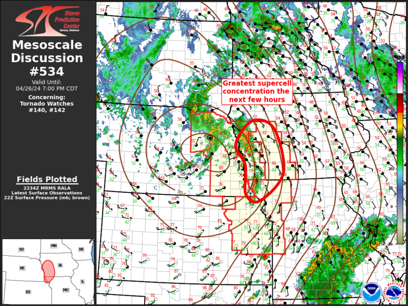
Mesoscale Discussion 0534
NWS Storm Prediction Center Norman OK
0536 PM CDT Fri Apr 26 2024
Areas affected...Mid Missouri Valley
Concerning...Tornado Watch 140...142...
Valid 262236Z - 270000Z
The severe weather threat for Tornado Watch 140, 142 continues.
SUMMARY...Supercells, and attendant severe threat, will spread
northeast across western IA/northwest MO.
DISCUSSION...Exit region of mid-level jet is spreading northeast
ahead of ejecting short-wave trough. Boundary-layer air mass is
stubbornly recovering across central IA where mid 50s surface dew
points persist. Partial clearing across southwestern IA has
contributed to surface temperatures warming into the lower 70s, and
lower 60s dew points have now advanced into Crawford/Audubon County.
Forecast soundings suggest 60F dew points are needed for
surface-based buoyancy and additional recovery is expected into
central IA later this evening.
Around a half dozen well-defined, long-lived supercells are now
advancing east of the MO River into western IA. Per 60F dew points,
air mass immediately downstream is adequately buoyant for
maintaining robust updrafts. Tornado threat continues until updrafts
encounter cooler conditions farther downstream.
..Darrow.. 04/26/2024
...Please see www.spc.noaa.gov for graphic product...
ATTN...WFO...DMX...EAX...FSD...OAX...TOP...
LAT...LON 42589550 42329451 40819410 39869514 40099577 41079581
41769625 42589550
Read more
SPC MD 533
MD 0533 CONCERNING SEVERE POTENTIAL...WATCH NEEDED SOON FOR CENTRAL TEXAS...SOUTHEASTERN OKLAHOMA...ARKLATEX
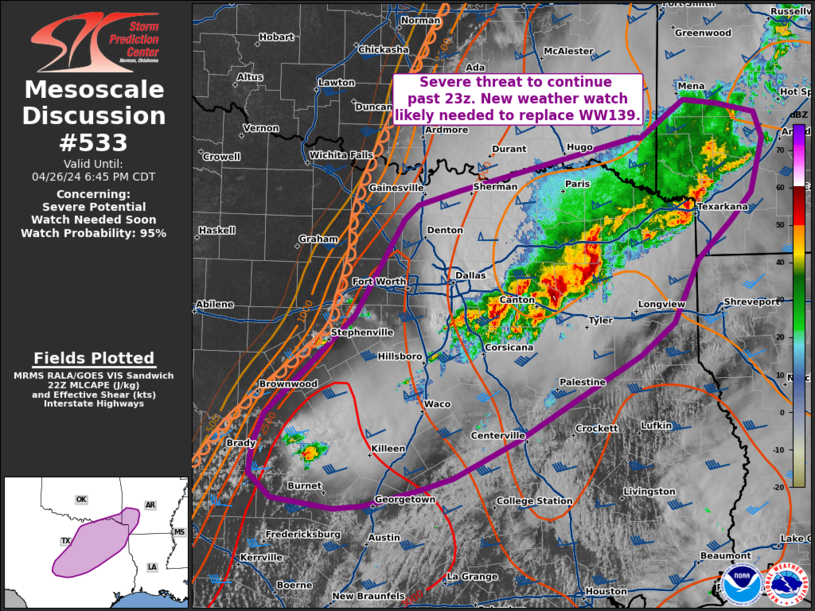
Mesoscale Discussion 0533
NWS Storm Prediction Center Norman OK
0513 PM CDT Fri Apr 26 2024

Areas affected...central Texas...southeastern Oklahoma...Arklatex

Concerning...Severe potential...Watch needed soon

Valid 262213Z - 262345Z

Probability of Watch Issuance...95 percent

SUMMARY...The severe threat will likely continue past 23z. New
weather watch will be needed to replace WW139 soon.

DISCUSSION...A cluster of storms is ongoing from Forreston, TX to
Sulphur Springs, TX. These storms have produced reports of hail with
transient rotation embedded with the line. This complex has modified
the airmass, which is apparent in surface observations and visible
satellite. This cluster will likely continue to maintain severe
intensity with potential for damaging wind, hail, and a tornado as
it moves northeastward within the core of the low-level jet into the
Arklatex region.

Further west along a surface dryline, agitated cu can be observed
with potential for new thunderstorm development in the next couple
of hours. Given the modified airmass to the north and northeast of
ongoing convection, the best potential for new development of strong
thunderstorms will be along the southwestern fringe of WW139. This
area will become increasingly displaced from the low-level jet
through the evening, but will still reside in a region of unstable
air, amid steep lapse rates and strong deep layer shear. These
storms will be capable of very large hail and damaging winds, and
perhaps a tornado. A new weather watch will be needed to encompass
this threat soon.

..Thornton/Edwards.. 04/26/2024

...Please see www.spc.noaa.gov for graphic product...

ATTN...WFO...LZK...SHV...TSA...HGX...FWD...OUN...EWX...SJT...

LAT...LON   31219903 31509891 32459791 33379736 33529719 33669673
            33759634 34159474 34169465 34519415 34479377 34389334
            34149325 33619340 33359363 32979402 32379430 32079467
            31819511 31259607 30899679 30769721 30639779 30609812
            30709881 30929906 31219903
Read more